
 Landmarks Preservation Commission311Search all NYC.gov websites


Press Release
FOR IMMEDIATE RELEASE:
December 18, 2017
CONTACT:
lpcpressoffice@lpc.nyc.gov, (212) 669-7938
LPC Makes Data On All Historic Buildings More Accessible With New, Enhanced Interactive Map
Discover NYC Landmarks, which now includes detailed information on the nearly 34,000 buildings located in historic districts, makes it easier for the public to explore the City’s wide range of designated historic buildings.
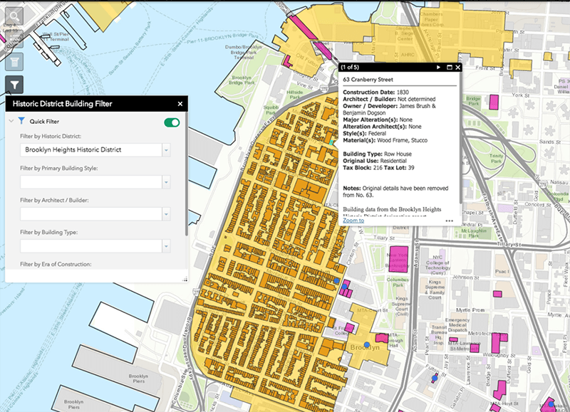
NEW YORK –– Today, the New York City Landmarks Preservation Commission (LPC) launched a new, enhanced version of its interactive map Discover NYC Landmarks that for the first time includes easily accessible and detailed information on each of the nearly 34,000 historic buildings within the City’s 141 historic districts. This release complements the map’s existing information on the more than 1,400 individual landmarks, and provides an unparalleled resource for understanding and exploring the city’s built heritage. The LPC’s web map is based on the largest and most comprehensive historic building data collection created by any municipal preservation agency in the United States.
“The launch of the enhanced web map will not only allow for a greater appreciation and understanding of our city’s rich architectural and cultural heritage, but it also brings greater transparency, efficiency, and public access to the agency,” said Landmarks Preservation Commission Chair Meenakshi Srinivasan. “This information is invaluable to all stakeholders, including homeowners who want to know more about their buildings, community groups, preservation advocates, historians, academics, and anyone who walks through New York City’s neighborhoods and marvels at our buildings.”
The Discover NYC Landmarks map, which is designed to be accessible from computers, smartphones, and tablets, allows the public to easily search, navigate and explore the City’s designated landmarks and historic districts. New features include pop-ups for each building in historic districts with information such as construction date, architect, style, building type and original use.
The map now also contains powerful new tools to search and filter historic district building data. Map users can search and filter by characteristics such as architectural style, architect, building type and era of construction. For example, with the new filtering tool, users can easily identify and visualize every apartment building in the Upper West Side Historic District or every Queen Anne Style rowhouse in the Bedford Historic District. This will allow for a greater understanding and appreciation of New York City’s historic buildings and neighborhoods.
The new building data featured on the map is the result of LPC’s Historic Building Data Project, funded by The New York Community Trust. Through this project, which was managed by LPC’s GIS Administrator and Planning Analyst Daniel Watts, staff and fellows compiled and transferred building-by-building information from 50 years of the Commission’s historic district designation reports into a Geographic Information System (GIS) database. Prior to the LPC’s release, information about the buildings in historic districts was available, but in the form of scanned documents that could not be easily searched, compared or analyzed.
“Never has it been easier for the public to access information about our historic district buildings. With just a click of a mouse, users can learn a building’s age, architect, style, type and more,” said Lisa Kersavage, LPC Director of Special Projects and Strategic Planning. “The result is a highly accessible, robust and detailed set of information that can be easily searched and compared, allowing for a greater understanding of the City’s historic district buildings.”
“Curious New Yorkers who want to know the who, what, and when behind our City’s incredible historic buildings have a powerful new tool. And it’s free,” says Kerry McCarthy, The New York Community Trust program director overseeing historic preservation. “Thanks to our ongoing partnership with the City of New York, anyone can learn more about City historic landmarks, which helped create the modern preservation movement.”
The Discover NYC Landmarks map is part of a broader LPC initiative to increase efficiency and provide greater transparency and public access. During the past three years, the Commission has redesigned its application forms to make them more efficient and user-friendly, launched online search tools for permit applications and to determine whether a building is in a historic district, an online library of LPC’s more than 1,600 designation reports, a searchable database of Commission decisions on projects at landmark sites, and a dedicated website for the City’s archaeological collections. LPC now also posts applicant presentation materials on the website prior to public hearings and meetings so that the public has a chance to review them and submit informed testimony.
###
About the Landmarks Preservation Commission (LPC)
The Landmarks Preservation Commission is the mayoral agency responsible for protecting and preserving New York City’s architecturally, historically and culturally significant buildings and sites. Since its creation in 1965, LPC has designated over 36,000 buildings and sites, including 1,405 individual landmarks, 120 interior landmarks, 10 scenic landmarks, and 141 historic districts and extensions in all five boroughs. For more information, visit www.nyc.gov/landmarks and connect with us via www.facebook.com/NYCLandmarks and www.twitter.com/nyclandmarks.