
 Department of City Planning311Search all NYC.gov websites


Jerome Avenue Neighborhood Plan
The New York City Department of City Planning (DCP) is proposing a series of land use actions including zoning map amendments, zoning text amendments and City Map changes to support implementation of the Jerome Avenue Neighborhood Plan. The Plan, which is the subject of an on-going community engagement process, will create opportunities for new affordable housing and community facilities including new parkland, establish Mandatory Inclusionary Housing, diversify area retail, support small businesses and entrepreneurs, and promote a safe and walkable pedestrian realm. The rezoning and related actions seek to achieve the following land use objectives:
- Provide opportunities for high quality, permanent affordable housing with options for tenants at a wide range of income levels.
- Ensure that any new construction fits into its surrounding neighborhood context.
- Increase the opportunities to diversify neighborhood retail and services.
- Permit more density and a broader range of uses in two nodes to anchor the corridor and surrounding neighborhoods.
- Create special rules for new development along the elevated rail line to provide light and air along the corridor and ensure adequate distance between residential uses and the train.
- Create special rules for new buildings and street wall continuity and relief on irregular lots.
- Create a walkable, inviting commercial corridor by promoting non-residential ground floor uses and diverse retail to support community needs.
- Maintain zoning for heavy commercial and light industrial uses in areas to support mixed uses and jobs.
- Establish controls for transient hotels to ensure consistency with the goals and objectives of the rezoning.
Additionally, the Jerome Avenue Neighborhood Plan calls for strategic infrastructure and community investments. While not reflected as land use actions here, the Plan recommendations are all interrelated and support a broad, comprehensive vision for the study area.
The Jerome Avenue Neighborhood Plan calls for rezoning an approximately 92-block area which spans approximately 151 acres along Jerome Avenue and is generally bounded by E 165th Street to the south and 184th Street to the north, The affected area also includes portions of Edward L. Grant Highway, E 170th Street, Mount Eden Avenue, Tremont Avenue, Burnside Avenue and E 183rd. The area is defined by Jerome Avenue which runs north-south and from East 165th Street to East 184th Street and east-west connections which comprise the commercial corridors and provide key connections throughout the study area. The rezoning area includes portions of Community Boards 4, 5, and 7 in the Borough of the Bronx.
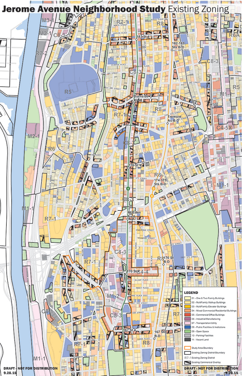
The current land use pattern along the Jerome Avenue corridor dates back almost a hundred years to when the area was developed to accommodate parking for the nearby dense residential developments. The surrounding residential communities were developed typically with 6-8 story apartment buildings and some lower-scale homes. At the time the residential communities were developed, parking was not permitted in residential buildings, and the Jerome Avenue corridor became a service district for these communities. The C8-3 and M1-2 zoning districts mapped along Jerome in 1961 helped freeze this land use pattern in place. Still today, much of this zoning does not permit the full range of options to fulfill the vision of the Jerome Avenue Neighborhood Plan. Residential development is currently not permitted in key nodes along the corridor and in areas that can accommodate growth and density. Commercial and retail development is limited in many parts of the study area. The streetscape is inconsistent as it is interrupted by uses that illegally occupy the sidewalk and the street and do not promote pedestrian safety or walkability. Many areas where residential development is permitted are characterized by underutilized properties developed with single-story commercial uses.
The existing zoning within the proposed rezoning area is composed of seven zoning districts:
- C8-3: General service district, typically comprised of automotive and other heavy commercial uses. Commercial FAR is permitted up to 2.0. Community facility FAR is permitted up to 6.5. Residential uses are not permitted.
- M1-2: Light manufacturing district, typically comprised of self-storage, warehousing, automotive repair, and other heavy commercial/light industrial uses. Commercial and manufacturing FAR is permitted up to 2.0. Community facility FAR is permitted up to 4.8. Residential uses are not permitted.
- C4-4: Regional commercial district permitting specialty and department stores. Commercial FAR is permitted up to 3.4. Residential FAR is permitted up to 3.44 (4.0 for Quality Housing). Community facility FAR is permitted up to 6.5
- R7-1: Mid-density residential district comprised of multi-family elevator and walk-up apartment buildings. Residential FAR is permitted up to between 3.44 and 4.0. Heights are regulated by the sky exposure plane, beginning at a height of 60 feet. Quality housing buildings can rise to a maximum of 85 feet. Community facility FAR is permitted up to 4.8.
- R8: High-density residential district comprised of multi-family elevator and walk-up apartment buildings. Residential FAR is permitted up to between 6.02 and 7.2. Heights are regulated by the sky exposure plane, beginning at a height of 85 feet. Quality housing buildings can rise to a maximum of 135 feet. Community facility FAR is permitted up to 6.5.
- C1-4 and C2-4 commercial overlays: Local retail district overlays, typically comprised of neighborhood-serving retail and service uses. Commercial FAR is permitted up to 2.0.
The Jerome Avenue Neighborhood Plan calls for the following land use actions:
-
Creation of the Special Jerome Avenue District to regulate irregular lots; control ground floor uses, curb cuts, and transparency; and regulate transient hotels.
Application of Mandatory Inclusionary Housing in proposed R7A, R7D, R8A, R9A and C4-4D (MIH Option, 1, 2, and Deep Affordability)
Changes to the City Map to facilitate the development of Corporal Fischer Park
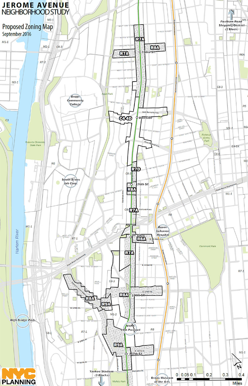
And the following Zoning Map Amendments:
-
Rezoning two full blocks and 17 partial blocks from C8-3 and R7-1 to R7A. R7A allows medium-density apartment buildings at a maximum FAR of 4.0 for residential uses and 4.6 for residential uses in areas mapped with Inclusionary Housing. R7A districts permit community facility FARs up to 4.0.
Rezoning two blocks from R7-1 to R7D. R7D allows medium-density apartment buildings at a maximum FAR of 5.6 for residential uses in areas mapped with Inclusionary Housing. R7D districts permit community facility FARs up to 4.2.
Rezoning 39 partial blocks from M1-2, C8-3, C4-4, R7-1, R8 to R8A. R8A allows medium-density apartment buildings at a maximum FAR of 6.02 for residential uses and 7.2 for residential uses in areas mapped with Inclusionary Housing. R8A districts permit community facility FARs up to 6.5.
Rezoning three full and 6 partial blocks from C8-3, M1-2, R7-1, and R8 and R9A. R9A allows high-density apartment buildings at a maximum FAR of 8.5 for residential uses in areas mapped with Inclusionary Housing. R9A districts permit community facility FARs up to 7.5.
Rezoning 21 partial blocks from 8-3, R7-1, and R8 to C4-4D. C4-4D is an R8A equivalent, and is a mid-density commercial district that permits residential uses up to 7.20 FAR in areas designated as part of the Inclusionary Housing program, commercial uses up to 3.4 FAR, and community facilities up to 6.5 FAR. Residential and mixed use buildings developed within the district are subject to bulk regulations governed by the R8A district.
Mapping C2-4 commercial overlays over portions of the proposed R7A, R7D, R8A, and R9A. C2-4 commercial overlays allow for local retail uses and commercial development up to 2.0 FAR and allow Use Groups 1-9 and 14, which include uses such as plumbing and electrical shops, small bowling alleys and movie theaters, funeral homes, small repair shops, printers, and caterers.
Public review of the land use component of the City’s multi-faceted Jerome Avenue Neighborhood Plan started on August 21, 2017. During the seven-month public review process (Uniform Land Use Review Procedure, or ULURP), the public has a chance to comment formally on the proposal. The proposal will now be referred out to Bronx CBs 4, 5 and 7 for 60 days to review, after which it will go to the Borough President, the City Planning Commission and the City Council.
| Milestone | Dates |
|---|---|
| Department of City Planning Certification | August 21, 2017 |
| Bronx Community Boards 4, 5 and 7 Resolution - Recommended to approve with conditions | October 27, 2017 |
| Borough President Recommendation - Recommended to approve with conditions | November 27, 2017 |
| Bronx Borough Board Recommendation - Recommended to approve | November 27, 2017 |
| City Planning Commission Public Hearing | November 29, 2017 |
| City Planning Commission voted to approve the |
January 17, 2018 |
| City Council Hearing |
February 7, 2018 |
| City Council Approval with Modifications* | March 22, 2018 |
*City Council Modifications
On March 6, 2018, the NYC City Council adopted the proposed map and text amendments (N180050(A), ZRXC180051(A) ZMX, C170305 MMX) with modifications to the maximum FAR allowed in R8A district. The City Council also established which MIH options will apply within the study area
- MIH Options: The City Council adopted MIH Options 1 and 3 within the area of the rezoning where MIH will apply. The Council removed MIH Option 2 from the application.
- MIH Option 1 requires that 25% of residential floor area be made available to households earning 60% of AMI, on average. There is an additional stipulation that 10% of residential floor area will need to be made available to households earning 40% of AMI, on average.
- MIH Option 3 requires that 20% of residential floor area be made available to households earning 40% of AMI, on average.
- Maximum FAR: The City Council modified the maximum FAR allowed in R8A district rezoned from R8. Today, R8 properties are permitted 7.2 FAR for quality housing buildings on wide streets. Currently, R8A permits only 6.02 FAR outside inclusionary housing areas. The Council modification allows those properties to maintain the maximum 7.2 residential FAR that they have today.
Environmental review, known as the City Environmental Quality Review process (CEQR), is an essential part of the planning process. CEQR is the City’s process for implementing the State Environmental Quality Review Act (SEQRA), through which City agencies review proposed discretionary actions to identify the potential effects those actions may have on the environment.
An environmental assessment of the Jerome Avenue Rezoning Proposal, the first step in the CEQR process, was conducted and determined that the proposal may have a significant adverse impact on the environment requiring the preparation of an Environmental Impact Statement (EIS) to enable the public and decision-makers to understand the nature and consequences of these potential environmental impacts. A draft scope of work for the EIS was developed, which lists the impact categories to be analyzed and how they will be studied. A public scoping meeting to receive comments on the draft scope of work was held on September 29, 2016.
The Final Scope of Work and Draft Environmental Impact Statement (DEIS) were published on Friday, August 19, 2017. The City Planning Commission will hold a public hearing on the DEIS prior to issuing the Notice of Completion of the Final Environmental Impact Statement (FEIS) and CPC vote at a date to be announced later.
![]() Items accompanied by this symbol require the free Adobe Acrobat Reader.
Items accompanied by this symbol require the free Adobe Acrobat Reader.