
 Department of City Planning311Search all NYC.gov websites


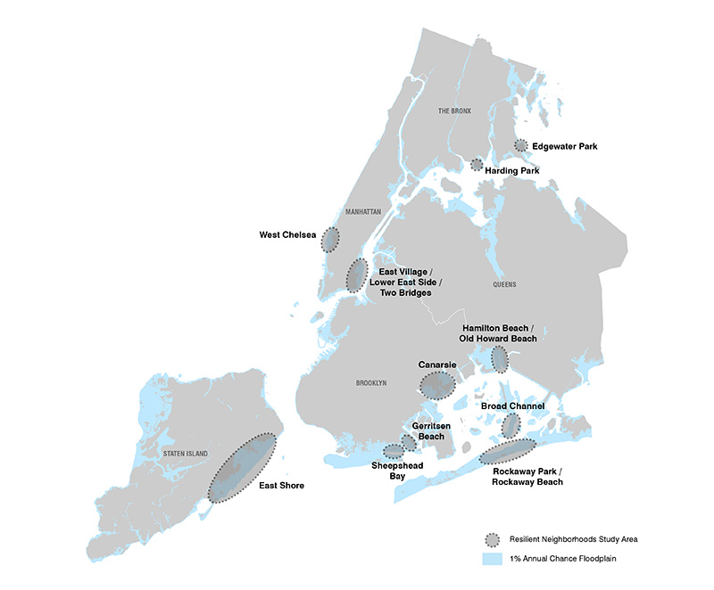
Resilient Neighborhoods
Resilient Neighborhoods: Gerritsen Beach, Resilient Neighborhoods: Sheepshead Bay, and Resilient Neighborhoods: Old Howard Beach entered public review on October 19, 2020.
Resilient Neighborhoods is a place-based planning initiative to identify neighborhood-specific strategies, including zoning and land use changes, to support the vitality and resiliency of communities in the floodplain and prepare them for future storms. Learn about other resiliency initiatives at City Planning.
Click on a study area for details on the neighborhood
Resilient Neighborhoods is one of many initiatives at City Planning to make New York City more resilient to flooding and climate change. Hurricane Sandy was a stark reminder of the vulnerability of the city’s coastal neighborhoods. Some communities suffered extensive damage, and numerous home and business owners continue to struggle to rebuild and recover. Others were largely unaffected by flooding in this storm, but remain at risk from future storms. Moreover, newly issued Federal flood maps, which show a substantially larger floodplain, combined with increasing flood insurance premiums present new economic challenges for many communities.
Following Hurricane Sandy, the City developed a detailed action plan for recovery from the storm and the long-term resiliency of New York City’s coastal communities, buildings, and infrastructure. The Department of City Planning (DCP) prepared a Flood Resilience Zoning Text Amendment, which was adopted in October 2013. This updated the zoning text based on new flood maps from the Federal Emergency Management Agency (FEMA) and removed zoning barriers that limited the ability of homeowners and developers to make necessary changes to better protect their new and existing buildings from floods. DCP is currently working with communities throughout the floodplain to update Flood Resilience Zoning.
The Resilient Neighborhoods initiative was launched in 2013 to work directly with floodplain communities to reexamine questions of land use, zoning, and development in light of a new understanding of coastal flood risks. In addition to changes to zoning and land use, the studies identify other opportunities for improving resiliency through infrastructure investment and other policies and programs. The studies are funded through the U.S. Department of Housing and Urban Development (HUD) Community Development Block Grant for Disaster Recovery.
This process builds on public input from other initiatives, such as New York State’s Community Reconstruction Program and the U.S. Department of Housing and Urban Development’s Rebuild by Design.
In addition to this initiative, DCP is conducting additional place-based planning studies through the PLACES initiative to foster diverse, livable neighborhoods with mixed-income housing and supporting services.
Each study considers the unique character of each community and the specific issues and opportunities, but is guided by a set of common goals:
Reduce flood risks
Develop zoning strategies and other tools to advance short-term, cost-effective investments that can make New York City’s building stock more resilient to severe storms and better protect our coastline.
Plan for adaptation over time
Climate change will increase coastal risks over time, including more tidal flooding in some areas. It is important to take measures to reduce the long-term vulnerabilities that neighborhoods will face over time.
Ensure neighborhoods are both resilient and vibrant
Encourage high-quality development that is both resilient and respects each neighborhood’s built environment, such as by limiting building height and improving public space.
The Resilient Neighborhoods initiative focuses on areas in all five boroughs, identified generally on the map above, where there was heavy damage from Sandy or substantial flood risks still exist. Each area was chosen because it presents specific land use, zoning, and resiliency issues that cannot be fully addressed by citywide zoning changes.
The City, led by the Mayor’s Office of Recovery and Resiliency (ORR), has developed a multifaceted plan for recovering from Sandy and improving the city’s resiliency–the ability of its neighborhoods, buildings and infrastructure to withstand and recover quickly from flooding and other climate-based hazards. As part of this effort, DCP is working with neighborhoods and government agencies to develop sound, ground-up frameworks for future development that align strategic planning priorities and broad, citywide resiliency goals with individual community needs.
Each Resilient Neighborhoods study includes a robust public outreach process, with City Planning working with affected communities to identify issues, set objectives, and shape and review recommendations. For more information on the outreach process, visit the webpage for an individual study area.
- View Frequently Asked Questions
- Related Project and Initiatives:
For more information contact: ResilientNeighborhoods@planning.nyc.gov
![]() Items accompanied by this symbol require the free Adobe Acrobat Reader.
Items accompanied by this symbol require the free Adobe Acrobat Reader.