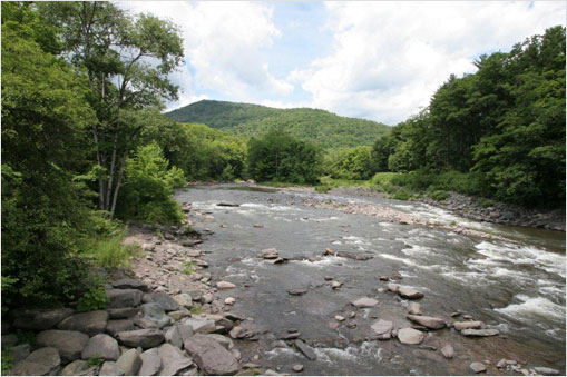
 November 26, 2013 CONTACT: Adam Bosch (845) 334-7868 Department of Environmental Protection and U.S. Geological Survey Announce Installation of New Stream Gauge in Lower Esopus at LomontvilleGauge in Lower Esopus Creek Will Provide Important Data for Future Stream ProjectsData on Flow and Turbidity is Viewable on USGS WebsiteThe New York City Department of Environmental Protection (DEP) and the U.S. Geological Survey (USGS) today announced that a new stream gauge was installed this month along the lower Esopus Creek at Lomontville, roughly 6 miles below Ashokan Reservoir. The gauge will provide flow and turbidity data, which will be posted in near-real time to the USGS and DEP websites. As part of the installation project, the ability to measure turbidity was also added to an existing gauge further downstream in Mount Marion, and that data will also be posted on the USGS and DEP websites. The Lomontville gauge was among the terms of a consent order signed in late September by DEP and the state Department of Environmental Conservation. The order required the gauge at Lomontville to be installed within a year. The City and USGS installed it within roughly six weeks. The new stream gauge is part of a national network – including roughly 40 gauges throughout the Catskills – that constantly gathers scientific data to better understand the hydrology of local streams. The gauges also help forecast stream flows, which enhanced an important flood-warning network that protects life and property across the region. “Scientific data collected by the new gauge will help stakeholders along the lower Esopus better understand how the creek reacts to normal flows and extreme storms, including the resulting fluctuations in turbidity at different points along the creek,” DEP Commissioner Carter Strickland said. “The gauge will also provide valuable information when water is released from Ashokan Reservoir to help ecology and support recreation, enhance flood protection ahead of large storms, and protect the water supply. That information will be easily accessible to the public, underscoring DEP’s commitment to be transparent about all its operations in the Catskills and Hudson Valley.” “Data from the Lomontville stream gauge will provide critical information to better understand the water resources and suspended sediment transport in the Lower Esopus Watershed,” said Ward Freeman, Director of the New York Water Science Center for USGS. “This will be part of a network of almost 8,000 USGS stream gauges across the nation used by water-resource professionals to better manage and protect the resource. This stream gauge will also provide supplemental data useful in National Weather Service River forecast operations at the Mt. Marion forecast point downstream.” The long-term data provided by the stream gauge will help in the development of a stream management plan for the creek and will enhance the environmental review that is about to begin. DEP has committed to fund the development of the plan, as well as provide $2 million for stream projects to improve the flow and the banks of the lower Esopus. Understanding the flow of the creek will help with the design of those stream projects. The gauge will also complement DEP’s weekly water-quality monitoring of two other sites along the lower Esopus – just above the Sawkill Creek and at the Saugerties Beach – that provide important data about creek conditions downstream of the reservoir. Online data from the Lomontville gauge can be accessed by clicking here. Data from the gauge in Mount Marion can be found by clicking here. DEP manages New York City’s water supply, providing more than one billion gallons of water each day to more than nine million residents, including eight million in New York City. The water is delivered from a watershed that extends more than 125 miles from the city, comprising 19 reservoirs and three controlled lakes. Approximately 7,000 miles of water mains, tunnels and aqueducts bring water to homes and businesses throughout the five boroughs, and 7,500 miles of sewer lines and 96 pump stations take wastewater to 14 in-city treatment plants. DEP has nearly 6,000 employees, including almost 1,000 in the upstate watershed. In addition, DEP has a robust capital program, with a planned $14 billion in investments over the next 10 years that will create up to 3,000 construction-related jobs per year. This capital program is responsible for critical projects like City Water Tunnel No. 3; the Staten Island Bluebelt program, an ecologically-sound and cost-effective stormwater management system; the city’s Watershed Protection Program, which protects sensitive lands upstate near the city’s reservoirs in order to maintain their high water quality; and the installation of more than 820,000 Automated Meter Reading devices, which will allow customers to track their daily water use, more easily manage their accounts and be alerted to potential leaks on their properties. For more information, visit nyc.gov/dep, like us on Facebook at facebook.com/nycwater, or follow us on Twitter at twitter.com/nycwater. | ||