Press Releases
FOR IMMEDIATE RELEASE
Press Release #12-75
Alternate Side Parking Regulations to be Suspended Indefinitely in Additional Storm-Damaged Neighborhoods
Regulations to be suspended indefinitely in Brooklyn Community Boards 6 and 18
Previously announced indefinite suspension in Brooklyn Community Boards 13 and 15 and Queens Community Board 14 continues
ASP regulations reinstated elsewhere
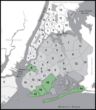
The New York City Department of Transportation, in conjunction with the Department of Sanitation, today announced that Alternate Side Parking (ASP) regulations would be suspended indefinitely in Brooklyn Community Boards 6 and 18 as of Thursday, Nov. 15, joining the previously-announced suspensions in Brooklyn Community Boards 13 and 15 and Queens Community Board 14. These localized exemptions will facilitate ongoing storm recovery efforts in areas with some of the most extensive damage. ASP regulations in other areas of the city were reinstated as of today, Wednesday, Nov. 14 in order to allow for necessary street maintenance.
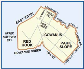
Brooklyn Community Board 6 includes the neighborhoods of Red Hook, Carroll Gardens, Park Slope, Gowanus, Boerum Hill and Cobble Hill, and is delimited by New York Bay and the East River on the west, Atlantic Avenue, Court Street, Fourth Avenue, Warren and Pacific Streets on the north, Prospect Park on the east and 15th Street and the Gowanus Canal on the south.

Brooklyn Community Board 18 includes the neighborhoods of Canarsie, Bergen Beach, Mill Basin, Flatlands, Marine Park, Georgetown and Mill Island and is delimited by Nostrand Avenue on the west, the Long Island Rail Road viaduct on the north, Van Sinderen Avenue and Louisiana Avenue on the east and Short Parkways on the south.
These following exempted areas were previously announced:
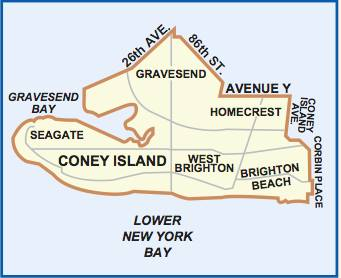
Brooklyn Community Board 13 includes the neighborhoods of Coney Island, Brighton Beach, Gravesend and Seagate, and is delimited by Gravesend Bay on the west, 26th Avenue, 86th Street and Avenue Y on the north, Coney Island Avenue and Corbin Place on the east, and Lower New York Bay on the south (indicating that the west side of Corbin Place will be exempt from ASP regulations, while the east side will not, for example).
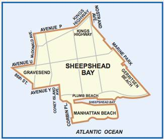
Brooklyn Community Board 15 includes the neighborhoods of Sheepshead Bay, Manhattan Beach, Kings Bay, Gerritsen Beach, Kings Highway, East Gravesend, Madison, Homecrest and Plum Beach, and is delimited by Corbin Place, Coney Island Avenue, Avenue Y, 86th street, Avenue U and MacDonald Avenue, Avenue P and Kings Highway on the north, Nostrand Avenue and Marine Park on the east, as well as by the Atlantic Ocean on the south.

Queens Community Board 14 includes the neighborhoods of Broad Channel, Breezy Point, Belle Harbor, Neponsit, Bayswater, Edgemere, Rockaway Park, Rockaway and Far Rockaway, and is delimited by Jamaica Bay to the north, the Nassau County line to the east and the Atlantic Ocean to the south. Note that as Staten Island does not have ASP, that borough is not affected by the reinstatement of regulations in the remainder of the city.
ASP Suspensions
—30—