
 Department of City Planning311Search all NYC.gov websites


Press Releases
For Immediate Release
October 19, 2020
Contacts:
Melissa Grace, Joe Marvilli – press@planning.nyc.gov (212) 720-3471
Making NYC More Resilient: Public Review Begins for DCP’s Important Zoning for Coastal Flood Resiliency
Proposed zoning would make new construction more resilient to disasters, including today’s COVID-19 pandemic; allow for better and faster building repairs; ensure seniors in nursing homes are better protected
NEW YORK – City Planning Commission (CPC) Chair Marisa Lago today announced the start of public review for Zoning for Coastal Flood Resiliency (ZCFR), newly proposed citywide zoning rules that would result in buildings that are better able to withstand and recover from major disasters and sea level rise and which will also translate to lower flood insurance costs.
“As we near its eight-year anniversary, Hurricane Sandy continues to serve as a painful reminder that we must continue to adapt to the ever-so-real threats of climate change. This includes updating our zoning to help New Yorkers build, and rebuild, more resiliently. This new zoning makes floodproofing in New York City’s neighborhoods much easier, whether you’re building a new home or apartment building, expanding your business, or simply elevating your boiler,” CPC Chair Marisa Lago said. “This new zoning also provides needed flexibility to address all types of future disasters, whether another climate event or today’s COVID-19 pandemic.”
ZCFR reinforces one of the most important lessons from Hurricane Sandy: Strong building codes make a big difference.
Currently, buildings are restricted by zoning regulations that do not take resiliency into account and thus force New Yorkers to choose between interior space and resiliency improvements. ZCFR will make it easier for buildings to meet or exceed modern resiliency codes without sacrificing their basement, for example, by adding some much-needed zoning flexibility.
Critically, the proposal will limit construction of new nursing homes in high-risk areas because of their vulnerable residents.
New York City has 520 miles of coastline, making many neighborhoods vulnerable to flooding during storm events and sea level rise. The proposed rules cover an area that is home to 800,000 New Yorkers, more people than live in Boston and two times as many as in New Orleans. Because the proposal is a citywide text amendment, all 59 community boards and all five borough presidents are required to weigh in on the proposal.
DCP is also releasing Floodplain by the Numbers, a report highlighting the long-term recovery progress and resiliency challenges facing the city’s diverse waterfront communities, including the fact that homes built prior to flood-resistant codes suffered higher average costs more than double those constructed to modern resiliency standards.
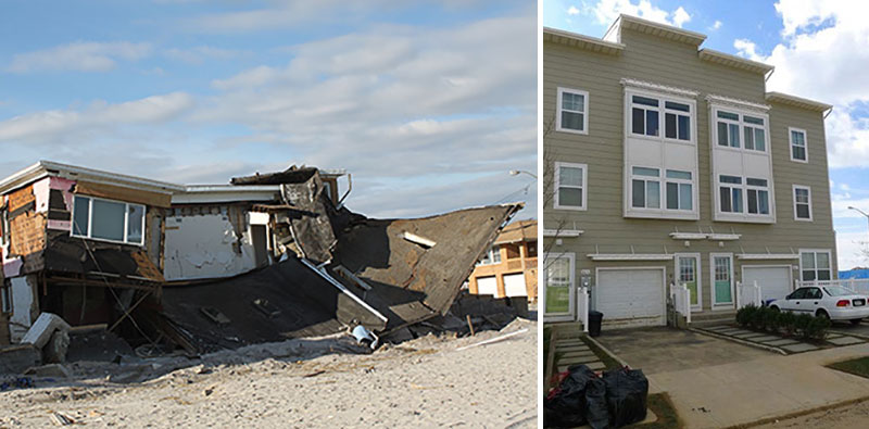
As you can see in the photograph of two structures in the Rockaway section of Queens below, on the left, homes constructed prior to modern resiliency codes suffered far more damage than buildings constructed to today’s resiliency standards, like the one seen on the right.
ZCFR would improve and make permanent resilient zoning provisions initially put in place to help the city recover from Sandy. Since 2016, planners at the Department of City Planning have spoken with about 3,000 New Yorkers at more than 225 events, including with elected officials, community boards, civic associations, non-profits, architects and engineers, garnering ideas and feedback from the public to develop and strengthen the proposal.
The proposal’s four main goals:
- Encourage resiliency in the current and future floodplain: ZCFR would expand the area where flood resilient zoning provisions apply, so that buildings in both the city’s 1% annual chance floodplain and 0.2% annual chance floodplain, those areas of New York City that, by 2050, are also expected to have a 1% chance of a flood event in any given year, can meet or exceed the flood-resistant construction standards set by FEMA or NYC’s Building Code. This expanded floodplain increases the number of buildings that could be retrofitted to resiliency standards by nearly 50%, allowing building owners throughout the city’s floodplain to proactively raise living space and important equipment out of harm’s way.
- Support long-term resilient design of all building types: Flexible zoning would allow building owners to raise habitable spaces and other building support features above expected flood elevations, without causing poorly designed, tall and narrow structures that don’t match neighboring homes. Regulations would incentivize active uses to be kept at the sidewalk level, and floodproofed ground floors with improved streetscapes
- Allow for adaptation over time through incremental retrofits: ZCFR would allow buildings to elevate or relocate important mechanical, electrical, and plumbing equipment, or backup systems like generators, above the expected height of floodwaters. This can be done either within the building, atop of the structure, or on a separate platform.
- Facilitate future recovery by reducing regulatory obstacles: As seen by the COVID-19 pandemic, disasters arrive in all forms. Rather than writing new emergency provisions each time a crisis strikes, ZCFR would place recovery provisions in the Zoning Resolution, so they can be quickly selected based on the issues caused by the disaster and recovery period. These provisions include cutting down on red tape and paperwork, and allowing additional time for an affected, grandfathered business to reopen, even if it doesn’t conform with current zoning.
In parts of the city that fall within the 1% floodplain, ZCFR would limit the siting of new nursing homes to lessen both the health consequences and logistical challenges of evacuating this particularly vulnerable population. Existing nursing homes in the floodplain can build enlargements of up to 15,000 square feet, allowing for modest improvements like resiliency measures.
Through these changes, ZCFR expands temporary rules that were adopted by the City in 2013, months after Sandy. The temporary rules are set to expire one year after FEMA’s new flood maps are released, likely in 2024.
“Most of New York City’s homes and buildings were constructed at a time when we knew far less about the threats posed by flooding,” said Jainey Bavishi, Director of the Mayor’s Office of Resiliency. “These new, more flexible rules were designed with climate change in mind and will make it easier for New Yorkers to strengthen their buildings with resiliency retrofits. We encourage all New Yorkers to learn more about their flood risks at FloodHelpNY.org and to enroll in flood insurance.”
“We’ve seen firsthand the devastating impact climate change can have on our City’s coastal communities,” said Department of Buildings Commissioner Melanie E. La Rocca. “We commend the Department of City Planning for proactively working to help New Yorkers in flood-prone neighborhoods better protect their homes and livelihoods.”
In addition to ZCFR, DCP is also starting public review for zoning changes in three neighborhoods as part of DCP’s Resilient Neighborhood Initiative – Gerritsen Beach and Sheepshead Bay in Brooklyn, and Old Howard Beach in Queens. These actions address resiliency challenges that are specific to the conditions found in these areas:
- In Gerritsen Beach, zoning changes, including the establishment of a new Special Coastal Risk District, are proposed to limit future density and cap building heights at 25 feet above the flood elevation to more closely match the area’s built character.
- In Sheepshead Bay, the existing Special Sheepshead Bay District would be updated to align it with ZCFR and prohibit below-grade plazas, which are especially prone to flooding.
- In Old Howard Beach, zoning changes are proposed to limit the construction of attached homes, which are harder to retrofit and elevate than detached homes because of their shared walls.
“We applaud the Department of City Planning for proposing these zoning changes that will increase community resiliency and save homeowners money on their flood insurance premiums,” said Christie Peale, CEO/Executive Director for the Center for NYC Neighborhoods. “These progressive changes will remove obstacles to neighborhood resiliency, not only for homeowners and their tenants who are currently at risk of flooding, but also for communities that will face additional flood risk by 2050. We are also gratified that this forward-looking framework will allow for flexible zoning to allow homeowners to retrofit their properties in a manner that maintains neighborhood integrity.”
“Our city is grappling with the impact of COVID-19 and has not yet fully recovered from Superstorm Sandy. These are stark reminders that climate change is here, and we must ensure that our coastline is resilient. These proposed zoning changes will help buildings better withstand flooding and storms, shortening the path for New Yorkers to return home or reopen their business after a disaster,” said Jessica Katz, Executive Director of Citizens Housing & Planning Council.
“Coastal cities across the nation are struggling to provide affordable housing to millions of low and moderate income households, and are concurrently struggling to preserve existing affordable housing stock, particularly rental, from significant risk from natural hazards such as flooding and rising sea levels,” said Laurie Schoeman, National Director, Resiliency and Disaster Recovery, Enterprise Community Partners. “The future of flood-prone communities will depend on the creativity and innovation that can be brought forward to ensure building owners and communities are incented to invest in resiliency strategies to protect this critical housing inventory. The land use zoning framework New York City’s City Planning team is deploying is creative, forward looking and a scalable solution to protect housing in flood-vulnerable communities across the nation.”
“Zoning for Coastal Flood Resiliency in New York City is an important step towards reducing barriers to resilient, nature-based waterfront design and allowing for needed resiliency in flood zones. We applaud this commitment to more resilient communities and shorelines. At a time when our region’s waterfronts are rapidly changing amidst the rising challenges of climate change, these zoning changes are a key part of driving sound waterfront design, development and resilience across all communities,” said Cortney Worrall, President and CEO, Waterfront Alliance.
The launch of the seven-month public review process starts the clock for ZCFR, as well as the three neighborhood-specific actions. ZCFR will go to all 59 Community Boards for review, followed by the five Borough Presidents and Borough Boards. The three neighborhood-specific actions will only go before their respective local Community Boards and Borough Presidents. ZCFR and the three local actions will then go to the City Planning Commission for a public hearing and vote, followed by the City Council.