
 Department of City Planning311Search all NYC.gov websites


Transportation
What Is a Travelshed?
Access to public transportation is often thought of as a binary – either you have it, or you don’t – but we know it’s more complicated than that. The number of stations and types of transportation you can use, where they take you and how fast they get you there, are what really matter.
A travelshed is the geographic area that can be reached from a specific point, within a specific period of time. For example, a travelshed can show which job centers a resident from a particular neighborhood could reach within an hour-long commute.
About the Transit Travelshed
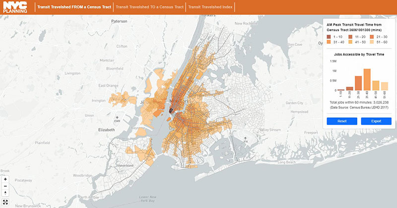
The Department of City Planning (DCP) Transit Travelshed shows the areas a New Yorker can reach by transit within one hour. It uses schedules of various public transit services, such as the subway, to provide a measure of transit accessibility for any location in New York City.
For example, it can demonstrate how connected a neighborhood is to jobs, or how much commuting time a proposed transit improvement could save.
Pick a Census tract in New York City in the interactive dashboard below to see your transit travelshed. The dashboard’s Travel Time to a Location shows the total population and number of workers who can travel to the selected Census tract by transit within 10-minute travel increments. View the Travel Time from a Location to see how many jobs can be accessed from the selected Census tract within 10-minute travel increments.
Methodology
The Transit Travelshed is developed through the open-source software OpenTripPlanner, with an input of General Transit Feed Specification schedule data published by 31 major transit operating agencies in the region. The model includes major public transit modes by which people get around the New York City metropolitan region, such as subway, bus, rail and ferry.
Based on residential densities and how people get to transit stations, the Transit Travelshed model assumes residents walk to transit within the five boroughs, and have the option of park-and-ride in the suburbs.