
 Department of City Planning311Search all NYC.gov websites


Gerritsen Beach
Resilient Neighborhoods: Gerritsen Beach entered public review on October 19, 2020. This proposal would update zoning code in the neighborhood of Gerritsen Beach to promote flood resiliency and allow for adaptation over time. Expanded permitted commercial uses on Gerritsen Avenue would include services helpful in storm preparation and recovery. New zoning districts, along with a new Special Coastal Risk District, would maintain appropriate limits on density in an area of current and future flood risk, and would promote contextual resilient construction on Gerritsen Beach’s small lots and narrow streets.
View theAs part of the Resilient Neighborhoods initiative, the Department of City Planning has been working with the community in Gerritsen Beach to identify changes to zoning and land use and other actions that support the continued vitality of this neighborhood, reduce its risk associated with coastal flooding, and ensure the long-term resiliency of its built environment. Gerritsen Beach was selected for the study not only because it was severely impacted by Hurricane Sandy, but also because of the very large expansion of the Federal flood maps and unique lot sizes and building types that present challenges to resiliency.
View the ![]() summary report on Gerritsen Beach..
summary report on Gerritsen Beach..
Visit the Gerritsen Beach Flood Risk Atlas.
In order to better understand the various challenges that homeowners in Gerritsen Beach face, the Department of City Planning worked closely with members of the community, local groups, and elected officials. The team presented to Community Board 15 and other local officials to inform residents of the study and gather early questions and concerns. This discussion was also a chance to identify local challenges that needed further study.
In order to provide feedback throughout this effort, City Planning convened a Community Advisory Committee (CAC) with representatives from several local groups, including the Gerritsen Beach Property Owners Association, Gerritsen Beach Cares, and Tamaqua Marina. The CAC met periodically to discuss the neighborhood’s post-storm recovery, zoning issues related to rebuilding after Hurricane Sandy, and a long-term resiliency vision for the neighborhood.
With community input through the CAC, Community Board, and elected officials, and through detailed flood risk and land use analysis, a planning framework was developed that identified land use and policy recommendations to help address neighborhood resiliency issues and provide a menu of retrofitting solutions that address Gerritsen Beach’s unique building stock.
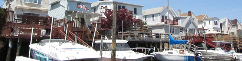
Gerritsen Beach is a maritime community in Southern Brooklyn nestled on a low-lying area along Plumb Beach Channel with houses set close together on shallow lots and narrow streets. Over 5,000 residents live in the Gerritsen Beach study area, which comprises the entire Gerritsen Beach peninsula south of Allen Avenue. Once a seasonal bungalow community, today Gerritsen Beach is a residential neighborhood predominantly characterized by single-family detached homes, with the exception of semi-detached and attached two- to three-story buildings in the northern portion of the neighborhood and one-story commercial buildings along Gerritsen Avenue, the community’s only commercial corridor. The Plumb Beach Channel is used for recreational boating and fishing, and residents have boats docked along Shell Bank Creek and the inner canal.
Gerritsen Beach was almost entirely inundated with surge waters during Hurricane Sandy. The tidal surge came in from the Gerritsen Inlet as well as over Plumb Beach and the Belt Parkway, flowing into Shell Bank Creek and Plumb Beach Channel and inundating the neighborhood with flood waters up to seven feet above grade. Basements and ground floor levels were flooded throughout the neighborhood, and a number of homes also experienced floodwaters on upper floors. The vast majority of the Gerritsen Beach study area was recently added into the floodplain under FEMA’s Preliminary Flood Insurance Rate Maps (PFIRMs), raising the number of at-risk buildings to over 1,800. Since many of these homes were not previously within the flood zone, they were not built to current flood resilient construction standards provided by FEMA and reflected in the New York City Building Code. Homeowners with federally-regulated mortgages may need to make significant investments in retrofitting these buildings to qualify for the lowest National Flood Insurance Program (NFIP) premiums. The 2013 ![]() Citywide Flood Resiliency Zoning Text Amendment was adopted on a temporary basis to remove many of the zoning barriers to making such retrofits; however, these changes do not fully address some of the challenges in Gerritsen Beach, and need to be made permanent. In addition to risk from coastal storm surge, some especially low-lying areas, particularly in the older (southern) section of the neighborhood, are vulnerable to future daily tidal inundation due to sea level rise.
Citywide Flood Resiliency Zoning Text Amendment was adopted on a temporary basis to remove many of the zoning barriers to making such retrofits; however, these changes do not fully address some of the challenges in Gerritsen Beach, and need to be made permanent. In addition to risk from coastal storm surge, some especially low-lying areas, particularly in the older (southern) section of the neighborhood, are vulnerable to future daily tidal inundation due to sea level rise.
Gerritsen Beach is a tight-knit community along Jamaica Bay, presently subject to coastal flood risk. The neighborhood is projected to see effects from sea level rise later this century. Implementation of resiliency measures can play a key role in mitigating these risks and enabling Gerritsen Beach to thrive in the future.
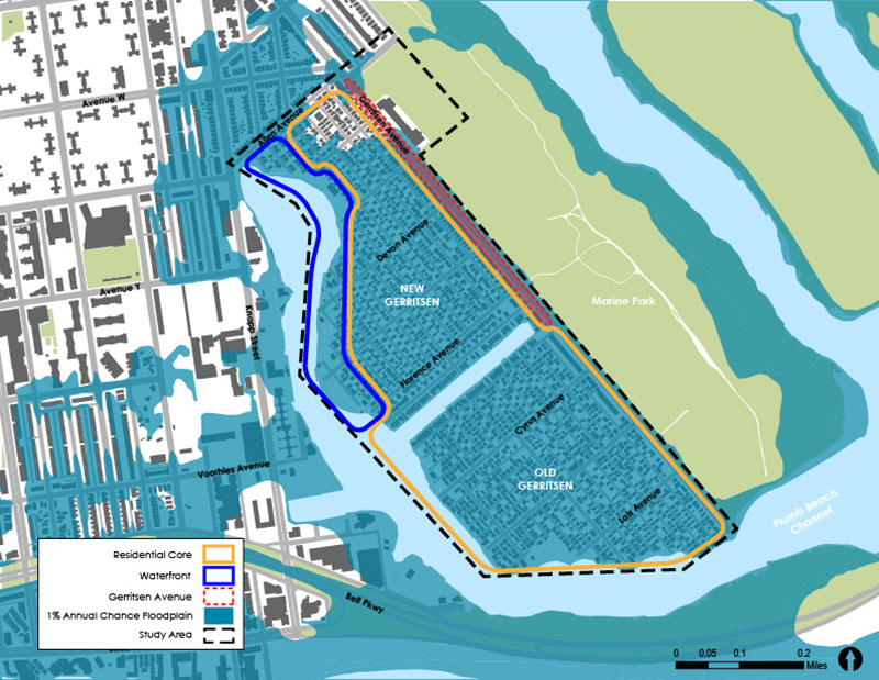
This resiliency framework was informed by the extensive public outreach conducted during the course of this study. The framework identifies three major areas where the DCP will focus its efforts to help Gerritsen Beach become more resilient through proposed zoning changes: the residential core of the neighborhood, the waterfront area in the northern portion of the peninsula, and along Gerritsen Avenue. In the Residential Core, existing zoning provisions available to buildings in the floodplain, coupled with a proposed new zoning envelope that better fits the existing character of this neighborhood and enables elevation above the floodplain, would foster the retrofitting of existing buildings to flood-resistant standards and would enable new developments that are more resilient. Additionally, the permitted uses along Gerritsen Avenue would be expanded to better serve the community with both transportation and commercial functions, especially in the aftermath of a storm. Finally, using zoning to allow only maritime and related commercial uses, with limited residential development, to locate along the Waterfront would support resiliency investments to the current building stock while fostering waterfront activity that can adapt to future risks. Further, the report discusses potential infrastructure improvements that could support flood impact mitigation and coastal protection in Gerritsen Beach and across the city.
The Resilient Neighborhoods Initiative is part of a broad range of efforts by the City to recover from Hurricane Sandy, promote rebuilding and increase the city’s resilience to climate-related events, including coastal flooding and storm surge. Recommendations from this program will be developed in close consultation with area stakeholders and build on other initiatives, including ONENYC and the Mayor’s Office for Recovery and Resiliency.
For more information contact: ResilientBrooklyn_DL@planning.nyc.gov
![]() Items accompanied by this symbol require the free Adobe Acrobat Reader.
Items accompanied by this symbol require the free Adobe Acrobat Reader.