
 Department of City Planning311Search all NYC.gov websites


East Shore Neighborhoods
On September 7, 2017, City Council adopted the East Shore Special Coastal Risk District and Rezoning which are now in effect.
As part of the Resilient Neighborhoods initiative, the Department of City Planning has been working with communities on the East Shore of Staten Island to identify zoning and land use changes to support neighborhood vitality and help residents and businesses withstand and recover quickly from future storms and flooding. The East Shore was selected for this initiative due to the wide-ranging impacts of Hurricane Sandy, the area’s diverse and aging building stock, and abundance of natural features, including hundreds of acres of wetlands, Bluebelts, and parks. Recommendations include a variety of zoning changes and other strategies to enable resilient buildings and promote retail corridors, as well as a targeted zoning proposal to limit the density of new development in the State Buyout Areas of Oakwood Beach, Graham Beach and Ocean Breeze.
View the ![]() summary report on the East Shore.
summary report on the East Shore.
Visit the East Shore Flood Risk Atlas.
The Department of City Planning engaged a wide variety of stakeholders in order to better understand the challenges facing East Shore residents and businesses. These efforts build on outreach by the City, State, and community organizations in the wake of Hurricane Sandy. Engagement on the part of NY Rising, Rebuild by Design, the New York City Mayor’s Office, and Borough President James Oddo, all helped to inform and contribute to DCP’s own public engagement process.
Outreach by the Resilient Neighborhoods team centered on a Community Advisory Committee (CAC) composed of thirteen community stakeholders from local civic, professional, environmental, and post-Sandy recovery organizations. Representatives of Community Boards 2 and 3, New Dorp Beach Civic Association, Midland Beach Civic Association, South Beach Civic Association, Staten Island Taxpayers Association, Natural Resources Protection Association, Stephen Siller Foundation, American Institute of Architects, Staten Island Chamber of Commerce, and Staten Island Economic Development Corporation all participated as members of the Advisory Committee. Many of the participants were also members of the successful NY Rising Committee. This helped to preserve institutional knowledge and leverage previous planning efforts.
Seven East Shore Community Advisory Committee meetings were held throughout the process, with each meeting focused on a different topic or challenge. Feedback from committee members provided a diversity of viewpoints. Participants commented on issues including zoning changes to support residential flood resilience, long term commercial viability for businesses located in the floodplain, the future of local parks and open spaces, major transportation issues on the East Shore, and protection of freshwater wetlands.
Building off the Advisory Committee process, the Resilient Neighborhoods team presented committee recommendations to elected officials, civic groups, and local business owners. More informal engagement also followed the CAC process, including discussions with residents at related public events convened by the US Army Corps of Engineers, the New York State Governor’s Office of Storm Recovery, and the New York City Parks Department.
The Department of City Planning held a resiliency open house for the East Shore residents and business owners on September 26, 2017 with participation from City, State, and Federal agencies. The goal of the event was to provide an update on the status of the variety of resiliency projects underway by multiple agencies in the East Shore. ![]() View the presentation.
View the presentation.
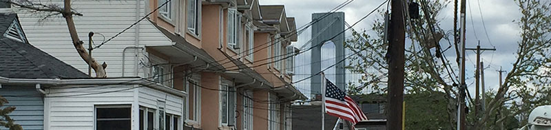
The East Shore is a coastal, low lying, and primarily residential area spanning four miles between Great Kills Park and the Verrazano Bridge. Coastal inundation during Hurricane Sandy was widespread and caused significant damage to thousands of homes and businesses. The scale of the devastation was due to several compounding factors including the proximity of residences to the coast and wetland areas, the volume and density of aging and unelevated homes, and low topography up to one mile inland. While these factors contributed to the extreme damage suffered as a result of Sandy, they are also considerable risk factors for coastal flooding in the future.
Flooding from Hurricane Sandy exceeded the existing federally-designated 1% annual chance floodplain. 2013 revisions to the Preliminary Flood Insurance Rate Maps (PFIRMs) led to a substantial increase in the number of homes and businesses within both the 1% and 0.2% annual chance floodplains. Today, over 10,000 residential units are within the 1% annual chance floodplain on the East Shore. The expansion of flood maps and changes to the National Flood Insurance Program (NFIP) will result in both significantly higher flood insurance premiums for many homeowners already a part of the program, as well as requirements for some homeowners to pay for flood insurance for the first time. The elevation of homes above their Base Flood Elevation may allow homeowners to avoid high flood insurance premiums, but this is often constrained by both the ability of the homeowner to pay for elevation and other site challenges. These issues are especially pronounced on the East Shore where aging bungalows, semi-detached, and attached housing are the predominant building types.
Construction of new, more resilient homes during the recovery process revealed several zoning issues, many of which were addressed by the 2013 Citywide Flood Text Amendment and the 2015 Special Regulations for Neighborhood Recovery text amendment. However both of these text amendments are not permanent, and additional strategies are needed to enable resilient development and create a long-term resilient future for the East Shore.
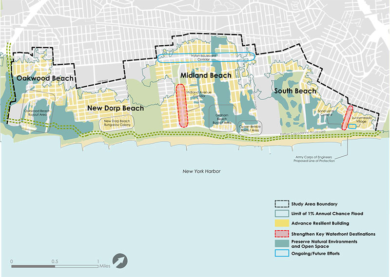
The East Shore Resiliency Framework, as shown below, includes a range of neighborhood-specific strategies that respond to the variation in Sandy damage, land uses, natural features, flood elevations, and infrastructure across the East Shore. These recommendations will guide the Department of City Planning’s work in 2017 and beyond, and will inform inter-agency coordination on resiliency issues. Check this webpage or find the contact information at the bottom of the page to learn about updates.
The proposed zoning for the East Shore includes both short-terms actions to be advanced to implementation in 2017 and other actions to be advanced for implementation in the coming years. In the near-term, the proposed zoning will focus on the New York State Buyout Areas. This proposal will create new rules for development on lots that did not participate in the buyout, while ensuring that homeowners that remain are able to make necessary repairs and resiliency investments. The proposal will also alter the existing commercial overlay in Graham Beach to match existing conditions. In the mid-term, the recommendations call for changes to residential zoning to help ensure that future development is resilient to coastal flooding, safe and accessible for residents, and in line with the character of the surrounding neighborhood, while promoting mixed-use residential and commercial development in areas where growth may be desirable.
The framework also includes and responds to projects already planned or underway to enhance the resiliency of the East Shore and protect its 40,000 residents from severe coastal inundation. Plans for coastal flood protection through the US Army Corps of Engineers Line of Protection will significantly reduce the risk of coastal inundation. New York State Buyout Programs in Oakwood Beach, Graham Beach, and Ocean Breeze aim to return neighborhoods to nature, providing a buffer to inland areas. The NYC Department of Environmental Protection’s Bluebelt network will bolster natural drainage and reduce flooding caused by rain events. Coupled with zoning and land use changes that will be implemented by DCP, these efforts represent a comprehensive vision for flood resiliency on the East Shore.
This framework was developed in partnership with the East Shore Community Advisory Committee, and serves as a long-term plan for zoning and land use changes in coordination with ongoing infrastructure investment.
- The Resilient Neighborhoods Initiative is part of a broad range of efforts by the City to recover from Hurricane Sandy, promote rebuilding, and increase the city’s resilience to climate-related events, including coastal flooding and storm surge. Recommendations from this program have been developed in close consultation with area stakeholders and coordination with other initiatives, including ONENYC and the Mayor’s Office for Recovery and Resiliency
- NYC Housing Recovery
- US Army Corps of Engineers South Shore of Staten Island Coastal Storm Risk Management Feasibility Study
- New York State Buyout and Acquisitions Program
- New York Rising Community Reconstruction Plan
- New York City Department of Environmental Protection Mid-Island Bluebelt
- NYC Parks Shoreline Parks Plan
- Rebuild By Design Living Breakwaters and Tottenville Dunes
For more information contact: ResilientSI_DL@planning.nyc.gov
![]() Items accompanied by this symbol require the free Adobe Acrobat Reader.
Items accompanied by this symbol require the free Adobe Acrobat Reader.